")

Download Google Earth Maps
* You must have the Google Earth app in order to view the above files
*download the map
THURSDAY 5 SEPTEMBER 2024
SHAKEDOWN
Length: 3.62 km
Road closing time: 7:00
First car due: 09:01
DESCRIPTION
A representative special stage, with the first part being fast, even on a hard surface. Then, as it goes uphill, the surface gets softer and faster, while the road is significantly wider.
NO TAPE, NO PUBLIC
Under the new FIA safety regulations, areas without safety nets, fencing, or tape are prohibited. Find your spot only in the designated areas marked with safety precautions or elevated spots.
INFO: Please ensure you arrive at your spot at least 30 minutes before the first competitive car starts. After that time, walking or moving on the special stage, including the start and stop, will be prohibited.
SPECTATOR ACCESS
As there is no intermediate access for the Shakedown, entry (on foot only) from the “Stop” will be allowed until 08:15. Prior to that, vehicles should park on the “Lamia-Domokos” road as per the instructions of the Police and the officials on duty.
Click to navigate
SHAKEDOWN STOP
FRIDAY 6 SEPTEMBER 2024
SS 1-4 ANO PAVLIANI
Length: 22.47 km
Timetable
Road closing time: SS 1 04:55
First car due: SS 1 07:58
SS 4 14:29
NO TAPE, NO PUBLIC
Under the new FIA safety regulations, areas without safety nets, fencing, or tape are prohibited. Find your spot only in the designated areas marked with safety precautions or elevated spots.
INFO: Please ensure you arrive at your spot at least 30 minutes before the first competitive car starts. After that time, walking or moving on the special stage, including the start and stop, will be prohibited.
ENJOY THE RALLY!
On the following pages are the access roads that organisers have chosen for spectators. Next to the number of each access road, there is a letter indicating the difficulty of the road surface. These are:
S= Soft= Passenger car (hatchback, sedan, etc.)
M= Medium= SUV
H= Hard= 4x4 or Enduro motorcycle
DESCRIPTION
The first 6.7 km takes place on a wide and fast road (the old Koumaritsi special stage), providing an excellent experience for both the crews and the spectators. Following this, there is a very narrow uphill section spanning 1.30 km, followed by a relatively uneventful but technical 5.0 km section that reconnects with last year's stage Pavliani (right before "Pyra Irakleous"). The following 9.5 km features a fast downhill stretch (following last year's route in the opposite direction) and ends after a right hairpin bend at the same point where the start had been in previous years.
Note: The special stage will be run twice. The conditions will be carefully reviewed, and the Organisation may propose that marshals allow spectators to move in the rally route’s direction for a limited time.
ACCESS ROADS
1 (S)
When coming from the Provincial Road of Oiti or from the Provincial Road of Sperhiada-Amfissa, you will reach the Nea Pavliani intersection. At the intersection, you will notice a basketball court and a tavern on your left. Reset the odometer and continue towards Ano Pavliani. After 1.5 km, take a right turn towards the village cemetery. The access road is tarmac and will be open until 180 m after the cemetery. Then there is a gravel road and after 500 m it meets the special at 6.71 km on a technical uphill section (a few meters after the access, in the direction of the stage, there is a hairpin bend).
The departure can be made from the ring road on the right.
Note: Park according to the marshals’ instructions. This is an ambulance evacuation route. Blocking it may cause the special stage to be cancelled.
Click to navigate
SS 1_4 ANO PAVLIANI 6,71 km
2 (S-M)
Coming from the Provincial Road of Oiti or from the Provincial Road of Sperhiada-Amfissa, you will reach the intersection of Nea Pavliani. There you will find a basketball court and a tavern on your left. Reset the odometer and continue towards Ano Pavliani. After 1.5 km, at the junction that leads to the village cemetery (on the right), make a left turn. Follow the road to the mountain shelter "ΦΟΙΒΟΣ". The road is a gravel one but in good condition. After 2 km, you will reach the 9.62km mark of the stage. This is a fast narrow stretch, and at 10.11 km of the stage, you'll come across the Monastery of Profitis Ilias, which is one of the limited viewpoints on this part of the special stage.
Click to navigate
SS 1_4 ANO PAVLIANI 9,62 km
3 (M)
After coming from Nea Pavliani or Kaloskopi, you will reach the shelter "Oiti". Reset the odometer. At 200 meters, you will find a junction. Turn right towards "Kastriotissa-Mavrolithari-Pyra". After 5 km, at a right turn, turn right backwards and follow an uphill gravel road in good condition for 4 km. This will lead to a crossroads where Pyra of Herakles is on the left, and 1 km to the right is the 16.67km of the special stage. There are several safe viewing opportunities there.
Click to navigate
SS 1_4 ANO PAVLIANI 16,67 km
4_a (S)
Coming from the Provincial Road of Oiti you will reach the intersection of Nea Pavliani. There you will find a basketball court and a tavern on your left. Reset youe odometer and turn left. In 2.20 km, on a left turn you will reach the STOP of the special stage. (ATTENTION: after this point parking will NOT be allowed - it is a rally route). Continue on the tarmac and at 1,20 km turn right backwards on an uphill gravel road. In 600 m you reach 21.95 km of the special route.
Click to navigate
SS 1_4 ANO PAVLIANI 21,95 km_a
4_b (S)
Coming from Kaloskopi in the direction of Pavliani, you will meet a junction on the left leading to Pyra-Stromi. Turn right and after 4 km you will find the uphill gravel road mentioned above leading to 21.95 km.
Click to navigate
SS 1_4 ANO PAVLIANI 21,95 km_b
FRIDAY 6 SEPTEMBER 2024
SS 2-5 DAFNI
Length: 21.67 km
Timetable
Road closing time: 06:05
First car due: SS 1 09:09
SS 4 15:40
NO TAPE, NO PUBLIC
Under the new FIA safety regulations, areas without safety nets, fencing, or tape are prohibited. Find your spot only in the designated areas marked with safety precautions or elevated spots.
INFO: Please ensure you arrive at your spot at least 30 minutes before the first competitive car starts. After that time, walking or moving on the special stage, including the start and stop, will be prohibited.
ENJOY THE RALLY!
On the following pages are the access roads that organisers have chosen for spectators. Next to the number of each access road, there is a letter indicating the difficulty of the road surface. These are:
S= Soft= Passenger car (hatchback, sedan, etc.)
M= Medium= SUV
H= Hard= 4x4 or Enduro motorcycle
DESCRIPTION
It starts with a relatively downhill section of 5.17 km in loose gravel until it crosses the village of Dafni. Then, there is a very technical and narrow section (including a difficult jump) up to the height of the village of Anatoli. From there, the stage continues with the last, particularly spectacular and pleasant 8.80 km downhill drive to the finish near the village of Marmara.
ACCESS ROADS
1 (S)
Coming from Pavliani or from Kaloskopi you will reach the "Oiti" shelter. After 200 m, turn right towards "Kastriotissa-Mavrolithari-Pyra". Pass through Pyra to reach Mavrolithari. As you leave the village, there will be a road going uphill to the right. Reset the odometer and continue on the main road. After 1.90 km, you will see the entrance sign to the village "Kastriotissa". Keep going, and after 5.38 km, follow the instructions of the Police. Park only after the gravel road, which leads to the START of the stage. To get to the START, walk back up to 30' before the 1st car is due and enter the gravel road on your left. After 390 m, you will reach the start of the special stage.
Click to navigate
SS 2-5 DAFNI ACCESS 1
2 (H)
Before the entrance of the village "Marmara", at the sign " Προς Πέρα Συνοικία", follow the road all the way to the right. After passing the first crossroads, drive for 240 meters, then leave a road on the right. After another 300 meters, turn right. Continue on a very narrow road, and after 1.20 km, you will reach the 21.25 km of the special stage (park on the road you came from).
Attention: Due to limited space for manoeuvring, you must wait for the special stage to be completed and for the sweeper car to pass before leaving in the direction of the village of Marmara.
Click to navigate
SS 2-5 DAFNI ACCESS 2 (21.25km)
FRIDAY 6 SEPTEMBER 2024
SS 3-6 TARZAN
Length: 23.37 km
Timetable
Road closing time: 08:15
First car due: SS 3 11:17
SS 6 17:48
NO TAPE, NO PUBLIC
Under the new FIA safety regulations, areas without safety nets, fencing, or tape are prohibited. Find your spot only in the designated areas marked with safety precautions or elevated spots.
INFO: Please ensure you arrive at your spot at least 30 minutes before the first competitive car starts. After that time, walking or moving on the special stage, including the start and stop, will be prohibited.
ENJOY THE RALLY!
On the following pages are the access roads that organisers have chosen for spectators. Next to the number of each access road, there is a letter indicating the difficulty of the road surface. These are:
S= Soft= Passenger car (hatchback, sedan, etc.)
M= Medium= SUV
H= Hard= 4x4 or Enduro motorcycle
DESCRIPTION
Fans were thrilled to see "Tarzan" back in the rally in 2021. The initial 10 kilometres of downhill terrain take place on a tough forest road, followed by about 4 kilometres of smoother gravel. Once the route reaches the intersection of Rovoliari and Rentina villages, the famous cobblestone path of Tarzan begins, which can challenge both dampers and tyres. The special stage finishes just before entering the village of "Palaia Giannitsou."
SPECTATOR ACCESS
1a (M)
Moving on the Provincial Road Lamia-Karpenisi, in Vitoli turn right on a concrete uphill road with a sign "Rovoliari". You will arrive at the village; after leaving it, continue for about 2 km on a gravel road and you will arrive 400 meters before the 14,81 km of the stage. Follow the instructions of the organisation and park your vehicle in the designated area.
Note: Park according to the marshals’ instructions. This is an ambulance evacuation route. Blocking it may cause the special stage to be cancelled.
Click to navigate
SS 13 TARZAN ACCESS 1a (14.81km Rentina)
1b (S)
To get to the 14.81 km special stage, starting from the village of Smokovo head towards the village of Rentina. At the entrance of Rentina there is a plane. Cross the village. After 1.64 km, you will come to a square where you will see a coffee shop on your right. Turn left here. Continue on this road for 480 m until you see a "Stop" sign at a fork. Take the road to the right. After travelling for 6.40 km, you will come to another fork with a sign for "Μονή Ρεντίνας" on the right. Take the left road. After 1.90 km, you will see a sign for "Δήμος Σοφάδων Όρια Ρεντίνας". Continue straight. After 2.91 km, police officers will block traffic. Follow their instructions and park your vehicle accordingly. From there, it's just a 440 m walk to the 14.81 km of the special stage.
Click to navigate
SS 13 TARZAN ACCESS 1b (14.81km Rovoliari)
2 (Μ)
To reset the odometer, head towards the "Region of Central Greece" building at the exit of Lamia to Karpenisi. After driving for 25.51 km, take a right turn towards Makrakomi. In another 3.02 km, turn left and continue straight at the roundabout after 600 m. After 100 m, turn right at the "Stop" sign. Drive for 800 m before turning right again. In 6.38 km, you will arrive at the village of "Tsouka". Make a full left turn after driving for 450 m and then a full right turn after 80 m. You will see the village cemetery on your left side after driving for 680 m. The road's surface will turn into gravel after driving for another 140 m.
2_a (M)
After driving for 850 m, turn right and then another right after 3.90 km (you will see a small house on your right). Finally, after driving for 5.78 km, you will reach the 19.64 km of the special stage.
Click to navigate
SS 3 -6 TARZAN ACCESS 2a (19.64km)
2_b (M)
In 4.25 km, turn right on the "white" concrete road. In 960 m, turn back to the right, and in 180 m, on a right-hand bend, turn left. In 4.77 km you will reach the 22.33 km of the special stage.
Follow the above link to reach the beginning of the gravel road and from there to reach 22.33 km. continue by following these instructions (2_b) without navigation.
SATURDAY 7 SEPTEMBER 2024
SS 7 RENGINI
Length: 28.67 km
Timetable
Road closing time: 05:13
First car due: SS 7 08:16
NO TAPE, NO PUBLIC
Under the new FIA safety regulations, areas without safety nets, fencing, or tape are prohibited. Find your spot only in the designated areas marked with safety precautions or elevated spots.
INFO: Please ensure you arrive at your spot at least 30 minutes before the first competitive car starts. After that time, walking or moving on the special stage, including the start and stop, will be prohibited.
ENJOY THE RALLY!
On the following pages are the access roads that organisers have chosen for spectators. Next to the number of each access road, there is a letter indicating the difficulty of the road surface. These are:
S= Soft= Passenger car (hatchback, sedan, etc.)
M= Medium= SUV
H= Hard= 4x4 or Enduro motorcycle
DESCRIPTION
It is identical to last year's special stage Elatia, but in the reverse direction. Key landmarks include the water crossing at 4.74 km of the stage and the very fast downhill 10.59 km to the finish, known as the Greek "Pikes Peaks", which many spectators have been eagerly awaiting to watch for more than two decades.
SPECTATOR ACCESS
1 (Μ-H)
When traveling from Modi to Elatia, take a left at the stop sign. After 1.45 km, you will pass through the village "Panagitsa." Keep going straight (after 480 m, the road becomes gravel), and at the shrine, turn left. After 2.7 km, at the T-junction, continue straight ahead. In 3.35 km, you will reach the 4.44 km of the special stage, 290 m, before a water splash.
Click to navigate
SS 7 RENGINI ACCESS 1 (4.44km)
2 (S-M)
From Livadia to Lamia, after passing the villages of Thourio, Chaeroneia and Davlia, at the roundabout turn diagonally right towards Atalanti. After about 7 km, where the junction to Elatia (left) and Sfaka-Katalima (right), turn left. Reset the odometer and after 5.95 km, where cypress trees on your right and a sign " Ι. Ναός Αγ. Αποστόλων ", turn right. After 170 m, turn diagonally left. At 130 m turn right; after 2.46 km the surface becomes gravel. In 80 m turn left and after 5.10 km you will reach the 5.47 km of the special stage. You can either watch from that point or, walking off the route to the left for 730 m, you can reach the well-known "water crossing".
Note: Park according to the marshals’ instructions. This is an ambulance evacuation route. Blocking it may cause the special stage to be cancelled.
Park on one side of the road and in the direction of departure.
Click to navigate
SS 7 RENGINI ACCESS 2 (5.47km)
3 (S)
On the road from Livadia to Lamia and after passing the villages of Thourio, Cheronia and Davlia, at the roundabout continue diagonally right towards Atalanti. After about 7 km, where you reach a crossroads to Elatia (left), continue straight on. After 5.10 km, turn left towards Kalapodi and Zeli. In 200 m, at the sign, turn left towards Zeli. In 3.70 km you will reach Zeli. Park on the right side of the square and continue on foot, as it is an ambulance evacuation road. In 700 m. at the fork, continue uphill to the left and in 200 m. again to the left, towards Profitis Ilias. In 1.10 km you will reach the 18.08 km of the special stage, where it turns from gravel to tarmac.
Note: Park according to the marshals’ instructions. This is an ambulance evacuation route. Blocking it may cause the special stage to be cancelled.
Click to navigate
SS 7 RENGINI ACCESS 3 (18.08km)
4 (Μ-Η)
When driving on the Provincial Road of Atalanti-Exarchos towards Elatia, you'll come to a junction where the road on the right leads to the stop of the special stage and the chapel of Saint Nektarios. At this junction, reset the odometer and continue straight. After 600 meters, make a right turn onto a gravel road. Then, after another 600 meters, at the fork, turn right. Continue for about 650 meters and take another right at the following fork. After approximately 350 meters, you will arrive at the FLYING of the special stage.
Follow the marshals' instructions to the spectators’ area, proceeding OF THE RALLY ROUTE in the DESIGNATED PATH (always behind the safety tapes).
NOTE: NO ACCESS FROM THE STOP TO THE FLYING LINE WILL BE ALLOWED
Click to navigate
SS 7 RENGINI ACCESS 4 (Finish)
SATURDAY 7 SEPTEMBER 2024
SS 8 THIVA
Length: 20.95 km
Timetable
Road closing time: 07:34
First car due: 10:37
NO TAPE, NO PUBLIC
Under the new FIA safety regulations, areas without safety nets, fencing, or tape are prohibited. Find your spot only in the designated areas marked with safety precautions or in elevated spots.
INFO: Please ensure you arrive at your spot at least 30 minutes before the first competitive car starts. After that time, walking or moving on the special stage, including the start and stop, will be prohibited.
ENJOY THE RALLY!
On the following pages are the access roads that organisers have chosen for spectators. Next to the number of each access road, there is a letter indicating the difficulty of the road surface. These are:
S= Soft= Passenger car (hatchback, sedan, etc.)
M= Medium= SUV
H= Hard= 4x4 or Enduro motorcycle
DESCRIPTION
This year's Thiva features a new layout, spanning a total length of 20.95 km and encompassing 54 intersections, without passing through the well-known "firing range." Generally, the stage maintains a familiar pattern, with consecutive bends on mostly soft gravel surfaces.
SPECTATOR ACCESS
1 (S)
On the Provincial Road Neochoraki-Schimatari, you pass through the village of Neochoraki in the direction of Asopia. At the last house of the village (on the right), reset the odometer. In 350 m you leave the gravel road on the left (where there is a yellow warehouse) that leads to the start of the special stage. After 500 m turn left onto a very good gravel road. In 500 m you will reach the 4.36 km of the stage.
Click to navigate
SS 8 THIVA ACCESS 1 (4.36km)
2a (H)
Moving on the Provincial Road of Thiva - Chalkida, turn at the junction for “Jumbo Thiva”. Reset the odometer and continue for 600 m. While driving on the tarmac you will pass a gravel road on the left and just after another gravel road on the right with a sign "XYTA ΘΗΒΑΣ" (landfill site), where you turn left. In 500 m you will see the beginning of the landfill and a sign (Ministry of Environment and Energy). At the beginning of the fence turn right on a hard uphill gravel road and after 1.23 you reach 6.90 km of the road.
Click to navigate
SS 8 THIVA ACCESS 2a (6.90km)
2b (M)
Moving on the Provincial Road of Thiva - Chalkida, turn at the junction for “Jumbo Thiva”. Reset the odometer and continue for 600 m. While driving on the tarmac you will pass a gravel road on the left and just after another gravel road on the right with a sign "XYTA ΘΗΒΑΣ" (landfill site), where you turn left. In 200m, you will find a medium-quality uphill gravel road on your right. Park until the first 400 m. on one side of the road and in the direction of departure. Continuing on foot for 300 m you will reach the 7.51 km of the special stage.
Note: Park according to the marshals’ instructions. This is an ambulance evacuation route. Blocking it may cause the special stage to be cancelled.
Click to navigate
SS 8 THIVA ACCESS 2b (7.51km)
3 (S)
Moving on the Provincial Road of Thiva - Chalkida turn at the exit for Thiva Hospital. Continue straight for 850 m and park according to the marshals’ instructions. Walking straight from the junction to a gravel road for 550 m. you reach the 9.20 km of the special stage.
Note: Park according to the marshals’ instructions. This is an ambulance evacuation route. Blocking it may cause the special stage to be cancelled.
Click to navigate
SS 8 THIVA ACCESS 3 (9.20km)
4 (S-M)
Moving on the Provincial Road of Thiva - Chalkida take the exit to the Hospital of Thiva. Continue straight ahead, and in 850 m. at the junction, turn right on an uphill gravel road. Follow the wide gravel road for 1.7 km. Then, at the fork, turn right and in 900 m you will reach 13.73 km of the special stage.
Click to navigate
SS 8 THIVA ACCESS 4 (13.73km)
5 (S)
Coming from both directions of the road ''Oplarchigou Vogli’’ (Οπλαρχηγού Βόγκλη), turn at the intersection where the Holy Church of Evangelistos Loukas (Ιερός Ναός Ευαγγελιστού Λουκά) is located, towards “Moschopodi/Forestry Office/Cemetery of Thiva” (Μοσχοπόδι/Δασαρχείο/Κοιμητήριο Θήβας). In 700m. you will pass the Forestry Office; continue straight on in the direction of the Moschopodi Theatre. In 800 m at a crossroads turn right towards the "CASTELLO" Restaurant. After 400 m park in an open area, following the officials' instructions. Walk uphill along a gravel road for 450 m and you will reach the 14.46 km of the special stage, at the well-known crossroads with the barrel.
Note: Park according to the marshals’ instructions. This is an ambulance evacuation route. Blocking it may cause the special stage to be cancelled.
Click to navigate
SS 8 THIVA ACCESS 5 (14.46km)
6 (S)
Coming from both directions of the road ''Oplarchigou Vogli’’ (Οπλαρχηγού Βόγκλη), turn at the intersection where the Holy Church of Evangelistos Loukas (Ιερός Ναός Ευαγγελιστού Λουκά) is located, towards “Moschopodi/Forestry Office/Cemetery of Thiva” (Μοσχοπόδι/Δασαρχείο/Κοιμητήριο Θήβας). In 700 m. turn right at a junction where the Forestry Office of Thiva is located. After 350 m continue straight on a wide and slightly uphill gravel road. After 1 km you will reach a junction; turn left. After 300 m, turn right at a fork. At 550 m, at another fork, turn left, and after 1 km, you will reach the 15.53 km of the special stage.
Click to navigate
SS 8 THIVA ACCESS 6 (15.53km)
7 (S)
Coming either from Thiva or from Erythres, turn at the junction to the village Neochoraki where you reset the odometer. Moving along the Provincial Road Neochoraki-Schimatari, in 4.9 km. you will pass a gravel road on the left that leads to the STOP of the special stage. Immediately afterwards you will have a traffic education park on your left and a football field on your right. At the end of both fences, turn left onto a smooth gravel road where there is a sign «ΠΡΟΣ ΠΙΣΤΑ ΜΗΧΑΝΟΚΙΝΗΤΟΥ ΑΘΛΗΤΙΣΜΟΥ MOTOCROSS ΘΗΒΑΣ». In 1,4 km follow the narrow road on the left, and immediately come out at a junction where you turn left. In 650 m you will reach the 20.61 km of the special stage.
Click to navigate
SS 8 THIVA ACCESS 7 (20.61km)
SATURDAY 7 SEPTEMBER 2024
SS 9 - 11 AGHII THEODORI
Length: 25.87 km
Timetable
Road closing time: 10:02
First car due: SS 9 13:05
SS 11 17:05
NO TAPE, NO PUBLIC
Under the new FIA safety regulations, areas without safety nets, fencing, or tape are prohibited. Find your spot only in the designated areas marked with safety precautions or in elevated spots.
INFO: Please ensure you arrive at your spot at least 30 minutes before the first competitive car starts. After that time, walking or moving on the special stage, including the start and stop, will be prohibited.
ENJOY THE RALLY!
On the following pages are the access roads that organisers have chosen for spectators. Next to the number of each access road, there is a letter indicating the difficulty of the road surface. These are:
S= Soft= Passenger car (hatchback, sedan, etc.)
M= Medium= SUV
H= Hard= 4x4 or Enduro motorcycle
DESCRIPTION
Starting at the same point as in the 2021 version (Kiafa Beka Settlement), the stage enters on a tarmac road after almost 6 km. After about 1.3 km, it turns right onto the familiar 3A surface section and continues until Panagia Prathi. Then, it goes left along a very narrow downhill section for 3.60 km, where it meets a dry river. It continues for the remaining 6.00 km, either crossing the river or following its bed, until reaching the finish at the settlement of Kato Harvati.
SPECTATOR ACCESS
1 (H)
Moving on the National Road Athens-Corinthos in the direction of Corinth, take the exit to Kineta. At the following junction turn right towards “Galini” (Γαλήνη). At the T junction turn left and in 450 m., at the next "T", where there are many signs on a fence, reset the odometer and turn right into the alley (Gerania Street), towards Agios Nikolaos. After 1.5 km, where a fork with a sign "Mary's Guesthouse" on a power pole, take the right-hand road, continuing on Gerania Street. At a junction 150 m later turn right. In 1.2 km continue straight ahead on a rough gravel road. In 1,3 km you leave a road on the right and continue straight ahead. After 5.7 km turn left. Continue on the wide gravel road, and in 3.9 km you will arrive at 5.03 km of the special stage.
Click to navigate
SS 9-11 AGHII THEODORI ACCESS 1 (5.03km)
2
The initial directions are common to both accesses
Moving on the National Road Athens-Corinthos in the direction of Corinth, take the exit to Aghii Theodoroi. In 360 m. you meet a toll station. After 170 m, at the STOP, turn left and after 1.73 km (just before the train tracks), turn left again on the first road. In 580 m, having "left" two roads on the right, turn diagonally left and after 220 m (having passed under the second bridge), turn left again. In 180 m. turn right on a narrow uphill road to "Kiafa Beka". After 2,77 km, you leave a gravel road on your right that leads to the start of the special stage.
From there, you have two options:
2a (S)
After 2.3 km, “leave” the gravel road on your left. Continue on the tarmac for 2.5 km. After walking a few meters, you will reach the 7.39 km of the special stage.
Note: Park according to the marshals’ instructions. This is an ambulance evacuation route. Blocking it may cause the special stage to be cancelled.
Click to navigate
SS 9-11 AGHII THEODORI ACCESS 2a (7.39km)
2b (Μ)
After 2.3 km turn left onto a gravel road. After 1.7 km turn right uphill. After 2.6 km you will reach the 8.45 km of the special stage.
Click to navigate
SS 9-11 AGHII THEODORI ACCESS 2b (8.45km)
3 (S)
On the main road that leads from Isthmos to Loutraki, turn right on “Karantani” street, right at the PepsiCo-ΗΒΗ factory. After 4.9 km you will reach a junction where there is a sign "ΝΕΑ ΠΟΛΙΤΕΙΑ καλώς ήρθατε”; turn right, towards the chapel of Metamorphosis of Sotiros. At this point the surface becomes gravel. Continue on the gravel road for 4.7 km and you will reach the 10.72 km of the special stage.
Note: Park according to the marshals’ instructions. This is an ambulance evacuation route. Blocking it may cause the special stage to be cancelled.
Click to navigate
SS 9-11 AGHII THEODORI ACCESS 3 (10.72km)
4 (Η-Μ)
Following the instructions for access 1a and reaching 5.3 of the special route, you can turn right and follow the uphill gravel road for 5.5 km to reach the Monastery of Panagia of Prathi and the 16.39 km of the special stage.
Click to navigate
SS AGHII THEODORI ACCESS 4 (16.39km)
SATURDAY 7 SEPTEMBER 2024
SS 10 LOUTRAKI
Length: 12.90 km
Timetable
Road closing time: 12:43
First car due: 15:46
NO TAPE, NO PUBLIC
Under the new FIA safety regulations, areas without safety nets, fencing, or tape are prohibited. Find your spot only in the designated areas marked with safety precautions or in elevated spots.
INFO: Please ensure you arrive at your spot at least 30 minutes before the first competitive car starts. After that time, walking or moving on the special stage, including the start and stop, will be prohibited.
ENJOY THE RALLY!
On the following pages are the access roads that organisers have chosen for spectators. Next to the number of each access road, there is a letter indicating the difficulty of the road surface. These are:
S= Soft= Passenger car (hatchback, sedan, etc.)
M= Medium= SUV
H= Hard= 4x4 or Enduro motorcycle
DESCRIPTION
This was last year's special stage Pissia with a different finish. It starts with a narrow uphill section of 3.30 km from the restaurant Platanos in Pissia to the church of Panagia Faneromeni. Afterwards it has a very fast downhill section of 4.30 km Then it enters a very downhill and technical section of about 5.00 km to finish at the first houses of the settlement of Ano Harvati.
SPECTATOR ACCESS
1 (M)
Starting from the village of Pissia, exit in the direction of “Schinos” (Σχίνος). In 0.9 km turn right on the narrow uphill road and in 2.10 km you will reach the 3.30 km of the special stage.
Click to navigate
SS 10 LOUTRAKI ACCESS 1 (3.30km)
SUNDAY 8 SEPTEMBER 2024
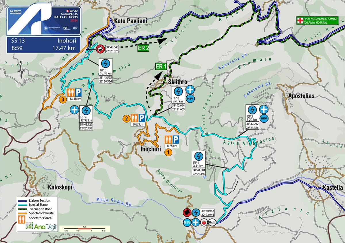
SS 13 INOHORI
Length: 17.47 km
Timetable
Road closing time: 05:56
First car due: 08:59
NO TAPE, NO PUBLIC
Under the new FIA safety regulations, areas without safety nets, fencing, or tape are prohibited. Find your spot only in the designated areas marked with safety precautions or in elevated spots.
INFO: Please ensure you arrive at your spot at least 30 minutes before the first competitive car starts. After that time, walking or moving on the special stage, including the start and stop, will be prohibited.
ENJOY THE RALLY!
On the following pages are the access roads that organisers have chosen for spectators. Next to the number of each access road, there is a letter indicating the difficulty of the road surface. These are:
S= Soft= Passenger car (hatchback, sedan, etc.)
M= Medium= SUV
H= Hard= 4x4 or Enduro motorcycle
DESCRIPTION
The first 3.41 km consist of an uphill stretch with a very good road surface. The next 2.83 km provide an enjoyable experience for spectators, winding through scenic areas with ample space for safe camping. This is followed by 3.70 km of a relatively narrow forest road, which briefly intersects with the tarmac Sklithro-Ιnohori road for 220 m before returning to the narrow gravel road, which is not particularly interesting for spectators. The stage finishes just outside the village of Kato Pavliani.
SPECTATOR ACCESS
1 (Μ-Η)
When you arrive at Inohori square from either Kastelia or Kaloskopi, turn right towards the church of Agia Ekaterini. Then, continue to the left, passing the guesthouse "Τα τέσσερα βουνά" on your right. After 150 meters, you will pass a stream and enter a narrow gravel road. Continue on this road for 2.3 kilometers, and you will reach the 8.25 km mark of the special stage.
Click to navigate
SS 13 INOHORI ACCESS 1 (8.25km)
2 (S)
Access to the intermediate tarmac section of the special stage is only possible from Inohori village. Click on the link below to arrive at a location 700 meters past the last house when leaving the village. Follow the marshals' directions to park and then proceed on foot along an uphill tarmac road for 500 meters. You'll reach the 9.62 km of the stage, where the cars transition from tarmac to gravel.
Access from Sklithro to 9.40 km of the special stage (where the cars transition from gravel to tarmac) will only be possible on foot (about 1.5 km long). Traffic will be stopped at the last house of the village due to the lack of parking space, the narrow road, and the fact that it is an ambulance evacuation route in case of emergency.
Click to navigate
SS 13 INOHORI ACCESS 2 (9.62km)
3 (Μ)
Entering the village of Nea Pavliani you will reach an intersection that leads straight to Ano Pavliani and left to Kaloskopi. At that point, where you will see a basketball court and a tavern, reset the odometer and turn left. After driving for 3.6 km, you'll reach a fork with a yellow sign and a church nearby. At this point, turn left. After 300 m, you'll encounter another fork where you should turn left again. Keep driving for 600 m, and you'll reach the 14.48 km mark of the special stage.
Click to navigate
SS 13 INOHORI ACCESS 3 (14.48km)
SUNDAY 8 SEPTEMBER 2024
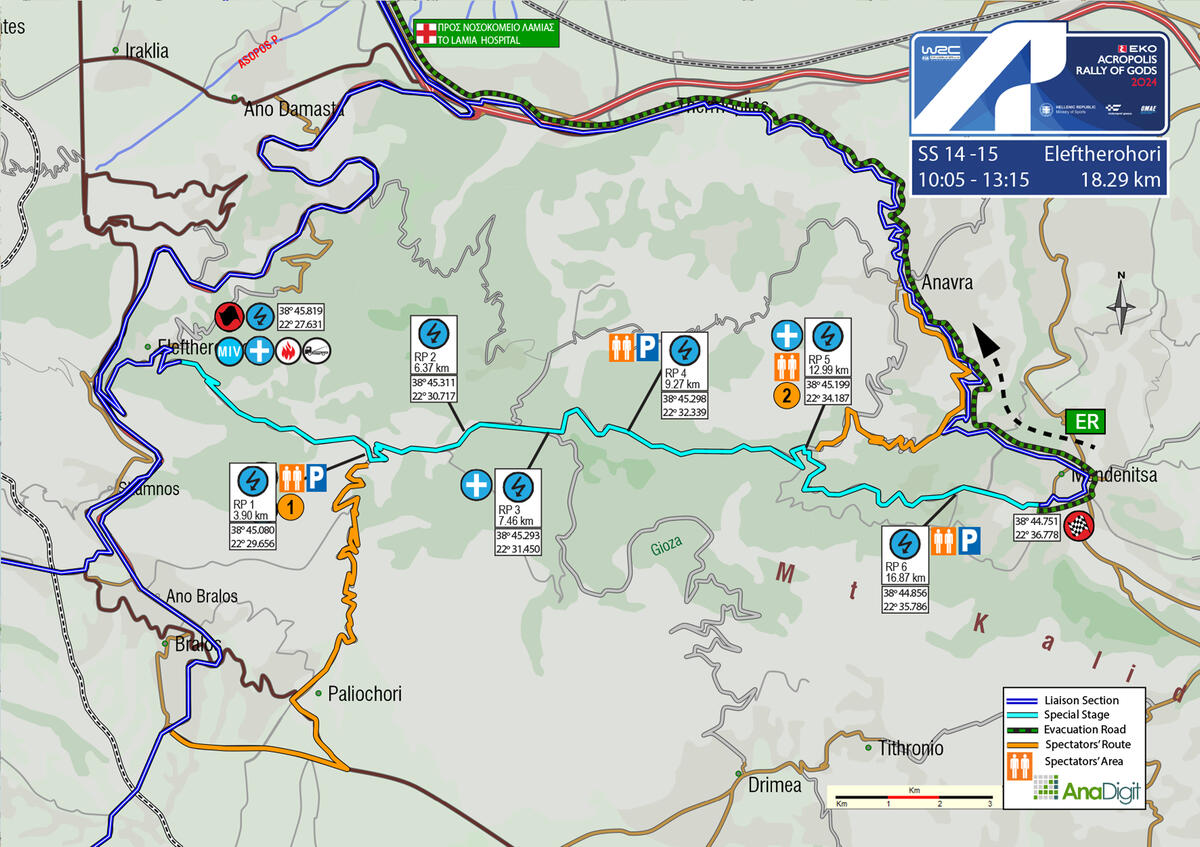
SS 14 - 15 ELEFTHEROHORI – WOLF POWER STAGE
Length: 18.29 km
Timetable
Road closing time: 07:00
First car due: SS 14 10:05
First car due: SS 15 13:15
NO TAPE, NO PUBLIC
Under the new FIA safety regulations, areas without safety nets, fencing, or tape are prohibited. Find your spot only in the designated areas marked with safety precautions or in elevated spots.
INFO: Please ensure you arrive at your spot at least 30 minutes before the first competitive car starts. After that time, walking or moving on the special stage, including the start and stop, will be prohibited.
ENJOY THE RALLY!
On the following pages are the access roads that organisers have chosen for spectators. Next to the number of each access road, there is a letter indicating the difficulty of the road surface. These are:
S= Soft= Passenger car (hatchback, sedan, etc.)
M= Medium= SUV
H= Hard= 4x4 or Enduro motorcycle
DESCRIPTION
One of the most iconic special stages of the Acropolis Rally, at least for the past 25 years. Starting outside Eleftherohori village, it ascends relatively quickly to the first lake (which is empty). Then it enters the forest, in a very narrow part up to the junction of Drimaea. Afterwards, the route is very fast until the height of the second lake (no water). It is very narrow downhill after about 1.5 km and up to the finish line.
The route now extends beyond the Monastery, where it usually ended, by an additional 650 meters, concluding at the outskirts of Mendenitsa village. The Wolf Power Stage will be awarded at this location.
SPECTATOR ACCESS
1 (M-H)
Heading from Lamia to Athens, on the National Road, take the exit towards Amfissa-Bralos, where you will pass through a toll station. In 160 m turn right towards Patra-Delfoi-Amfissa. After 12.50 km (at the junction on the left towards Eleftherohori), continue straight ahead and at 2.63 km, after a right turn, "leave" the junction on the right towards Skamno-Oiti-Pavliani. In 5,60 km turn left towards Livadia. In 2,90 km turn left towards Paleohori. In 800 m at the junction turn right and in 200 m turn right again. In 400 m, in front of the cemetery, the surface becomes gravel. In 600 m, at the junction turn left. At 1.80 km turn right (uphill road) and after 6.0 km you will reach the 3.90 km of the stage, at the lake (no water).
Please follow the organizers' instructions when parking to maximize the use of allocated parking spaces. Park on one side of the road and in the direction of departure.
INFO
• The entrance of spectators is prohibited inside the "Nevropolis" lake area, specifically through the delimited perimeter with wooden stakes.
Click to navigate
SS 14-15 ELEFTHEROHORI ACCESS (3.90km)
2 (M)
From Thermopyles head towards Anavra. Pass through the village and reset the odometer in front of the last house at the exit (on the right, with a playground). At 3.45 km (left turn), turn right on the uphill gravel road. At 3.20 km turn left and at 1.17 km you will reach the 12.99 km of the special stage.
Click to navigate
SS 14-15 ELEFTHEROHORI ACCESS 2 (12.99km)