")

Download Maps
Download Google Earth Maps
* You must have the Google Earth app in order to view the above files
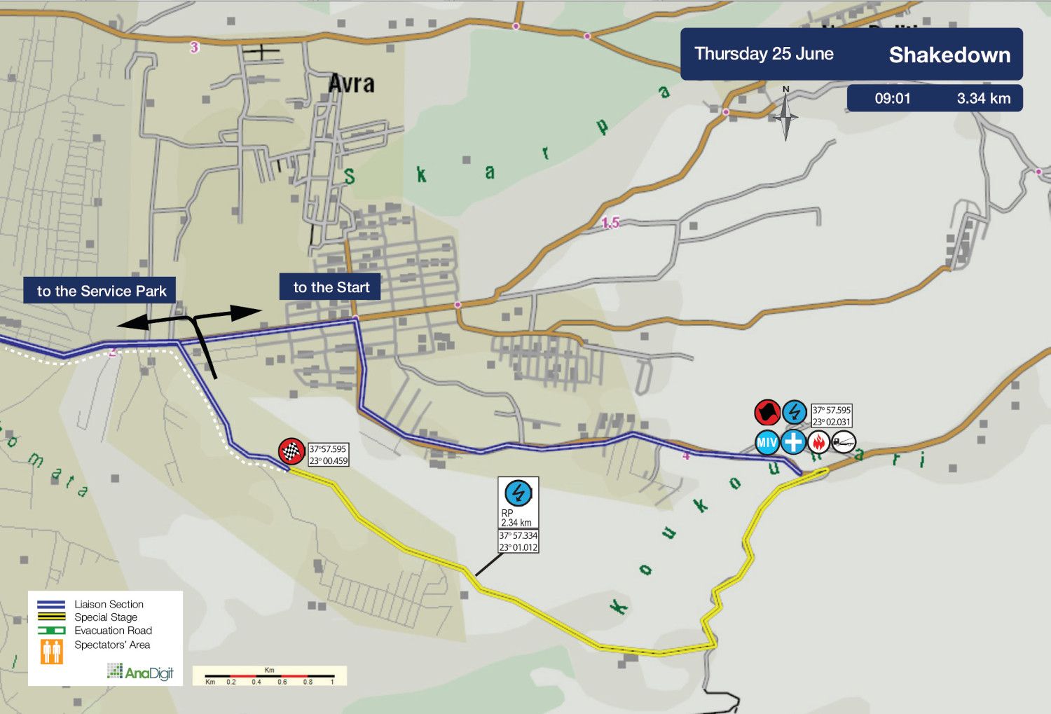
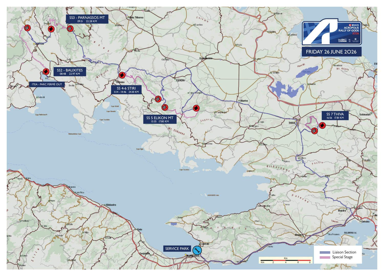
THURSDAY 25 JUNE 2026
SHAKEDOWN
Length: 3.34 km
Road closing time: 07:30
First car due: 09:01
NO TAPE, NO PUBLIC
Under the FIA safety regulations, areas without safety nets, fencing, or tape are prohibited. Find your spot only in the designated areas marked with safety precautions or elevated spots.
INFO: Select your viewing point at least 30 minutes before the start of the special stage. After this time, no movement will be permitted on the road, including in the start and finish areas.
Access points are categorized by road surface difficulty, with the category letter in bold next to each access number.
The categories are:
• S = Soft = Passenger car
• M = Medium = SUV
• H = Hard = 4x4 or Enduro motorcycle
DESCRIPTION:
Representative of the rally’s overall character, the Shakedown features almost every type of surface and characteristic crews will encounter during the special stages: from fast corners and narrow roads to a series of spectacular jumps midway through the stage, as well as a short passage through a village shortly before the finish.
SPECTATOR ACCESS
Heading along Eleftheriou Venizelou Avenue towards the centre of Loutraki, you will find the “NU AQUA S.A. / Eonio Loutraki” factory on your right. At the end of the factory premises, turn right onto Karantani Street. Reset your trip meter at this point.
After 800 m., at a junction, continue straight ahead on the tarmac road for approximately 4 km, until you reach a junction with a sign reading “NEA POLITEIA - Welcome!”, where you turn right.
After 600 m., at the small chapel, the surface turns to gravel. A further 500 m. later, at a fork, continue straight ahead. After 400 m., follow the road to the right onto a downhill section (watch out for the small stream crossing). Google Maps navigation ends at this point.
Continue for 800 m. along the wide gravel road until you reach the tarmac, where you turn right. After 1.2 km, park according to the organisers’ instructions and you will arrive at the change-of-surface section from tarmac to gravel, immediately after the start of the stage.
From there, you may either watch the start or walk 300-500 m. into the special stage -at least 1.5 hours before the first rally car starts- in order to reach a safe spectator viewing point.
Click to navigate
SHAKEDOWN
FRIDAY 26 JUNE 2026
SS 2 BAUXITES
Length: 22.97 km
Timetable
Road closing time: 05:48
First car due: 08:48
NO TAPE, NO PUBLIC
Under the FIA safety regulations, areas without safety nets, fencing, or tape are prohibited. Find your spot only in the designated areas marked with safety precautions or in elevated spots.
INFO: Select your viewing point at least 30 minutes before the start of the special stage. After this time, no movement will be permitted on the road, including in the start and finish areas.
Access points are categorized by road surface difficulty, with the category letter in bold next to each access number.
The categories are:
• S = Soft = Passenger car
• M = Medium = SUV
• H = Hard = 4x4 or Enduro motorcycle
DESCRIPTION
The classic Bauxites stage starts near the weighbridge area at the bauxite mines and, after 8.50 fast km, crosses the Amfissa tarmac road diagonally. Seven km further on, instead of turning left towards Karoutes, it continues straight and finishes above Prosilio.
Overall, this is a fast special stage, featuring a few rough sections but also many fully graded parts.
SPECTATOR ACCESS
1 (S)
On the road from Itea to Lamia, reset your trip meter in front of the Shell fuel station and continue towards Amfissa. After 12.20 km, turn left towards Amfissa. At the roundabout, take the second exit towards the Hospital and, after 700 m., turn left towards Lidoriki. After 1.30 km, continue straight towards Lidoriki and, 4.50 km later, you will reach the 8.78 km of the special stage, where the rally cars leave the tarmac and enter the gravel section.
Click to navigate
SS 2 BAUXITES ACCESS 1 (8.78 km)
2 (S)
The access route begins at Karoutes village entrance. After 700 m., follow the uphill fork to the left and, 300 m. later, on a left-hand corner (watch out for the bump), the surface turns to gravel. After 1.40 km, keep right and, 700 m. later, the road becomes tarmac again, before turning back to gravel after 2.30 km. After 6.80 km, you reach the 16.33 km of the special stage.
Click to navigate
SS 2 BAUXITES ACCESS 2 (16.33 km)
FRIDAY 26 JUNE 2026
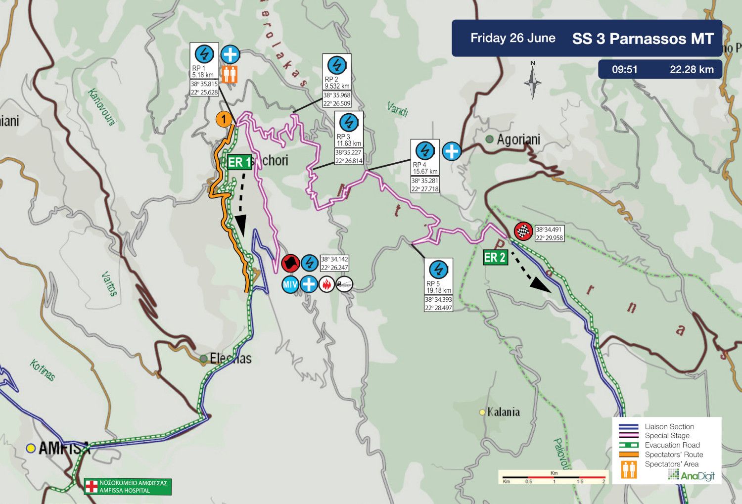
SS 3 PARNASSOS Mt
Length: 22.28 km
Timetable
Road closing time: 06:51
First car due: 09:51
NO TAPE, NO PUBLIC
Under the FIA safety regulations, areas without safety nets, fencing, or tape are prohibited. Find your spot only in the designated areas marked with safety precautions or in elevated spots.
INFO: Select your viewing point at least 30 minutes before the start of the special stage. After this time, no movement will be permitted on the road, including in the start and finish areas.
Access points are categorized by road surface difficulty, with the category letter in bold next to each access number.
The categories are:
• S = Soft = Passenger car
• M = Medium = SUV
• H = Hard = 4x4 or Enduro motorcycle
DESCRIPTION
The longest part of the special stage, Drosohori, was last used in 2012. It begins with a very fast, wide uphill section, featuring an excellent spectator spot at the 5th km of the stage, accessible from Drosohori village. What follows is a particularly demanding uphill section for both cars and crews, including 19 consecutive hairpins through the quarry area, before the road descends slightly and finishes above Eptalofos.
SPECTATOR ACCESS
1 (S)
Heading on the Amfissa-Bralos National Road, take the exit towards Eleonas village, where you should reset your trip meter and begin the route description. After 1.3 km, at the sign reading “Drosohori 8”, turn right. After 2 km, at a fork, continue straight ahead.
Follow the road to Drosohori village for 5.6 km until the road closure, then walk 1 km to the 5.18 km of the stage.
Caution: This road serves as an emergency ambulance escape route and must be kept clear at all times. Obstructing access may result in the cancellation of the special stage.
Click to navigate
SS3 PARNASSOS ACCESS 1 (5.18 km)

FRIDAY 26 JUNE 2026
SS 4 - 6 STIRI
Length: 24.18 km
Stage closure: 08:14
First car due: SS4 11:14
SS6 14:46
NO TAPE, NO PUBLIC
Under the FIA safety regulations, areas without safety nets, fencing, or tape are prohibited. Find your spot only in the designated areas marked with safety precautions or in elevated spots.
INFO: Select your viewing point at least 30 minutes before the start of the special stage. After this time, no movement will be permitted on the road, including in the start and finish areas.
Access points are categorised by road surface difficulty, with the category letter in bold next to each access number.
The categories are:
• S = Soft = Passenger car
• M = Medium = SUV
• H = Hard = 4x4 or Enduro motorcycle
DESCRIPTION
The stage starts just outside Distomo village. The opening 8.93 km are among the most spectacular of the rally. It is mainly a fast uphill section, featuring a very wide road and third-gear hairpins, elements that create ideal conditions for spectacular action.
The route then passes through a forest section of approximately 9 km, before reaching a narrower downhill stretch with consecutive hairpins through quarry sections, all the way to the finish on the Helicon plateau.
* THE STAGE IS RUN TWICE AND WILL NOT REOPEN BETWEEN THE TWO PASSES
SPECTATOR ACCESS
INFO: Access to the opening kilometres of the special stage from the start area will be closed 1 hour and 30 minutes before the stage start, as barriers will block the road and pedestrian access towards the wind turbines will not be permitted. After the road closure, access will be restricted to official safety vehicles only.
1 (M)
Approaching from Distomo, you arrive at Stiri village, where you should reset your trip meter at the monument in Agios Nikolaos square. Following the Distomo–Osios Loukas road towards Kyriaki, after 600 m. -at the point where there is a church on the left- turn left onto a downhill tarmac road.
At the next fork, where there is a yellow sign reading “OSIOS SYMEON”, follow the road to the right. After 300 m., at a junction with a white roadside shrine, turn diagonally left onto a concrete road. After 800 m., the surface turns to gravel.
At 1.5 km, ignore the uphill road on the right (Access 2) and continue straight ahead. After 1.2 km, at a junction, turn sharply right onto the rear road. After a further 900 m., you reach another junction, where you should park on the left-hand road. From there, after a 100 m. walk, you reach the 7.77 km of the special stage.
Caution: This road serves as an emergency ambulance escape route and must be kept clear at all times. Obstructing access may result in the cancellation of the special stage.
Click to navigate
SS 4-6 STIRI ACCESS 1 (7.77 km)
2 (M)
Approaching from Distomo, you arrive at Steiri village, where you should reset your trip meter at the monument in Agios Nikolaos square. Following the Distomo–Osios Loukas road towards Kyriaki, after 600 m. -at the point where there is a church on the left- turn left onto a downhill tarmac road.
At the next fork, where there is a yellow sign reading “OSIOS SYMEON”, turn right. After 300 m., at the junction with the white roadside shrine, turn diagonally left onto a concrete road. After 800 m., the surface turns to gravel.
At 1.5 km, turn sharply right onto an uphill road. After 450 m., at a fork, take the left-hand road. At 4.90 km, you reach the 15.60 km of the special stage.
Caution: This road serves as an emergency ambulance escape route and must be kept clear at all times. Obstructing access may result in the cancellation of the special stage.
Click to navigate
SS 4-6 STIRI ACCESS 2 (15.60 km)
3 (M)
Heading from Livadia towards Kyriaki, reach the Elikonas junction to reset your trip meter. After 2.3 km, pass the special stage STOP control on your right. 740 m later, at a left bend with a barrier and inverted STOP sign, turn right onto an uphill gravel road. After 500 m, reach the 23.24 km of the stage.
Click to navigate
SS 4-6 STIRI ACCESS 3 (23.24 km)
FRIDAY 26 JUNE 2026
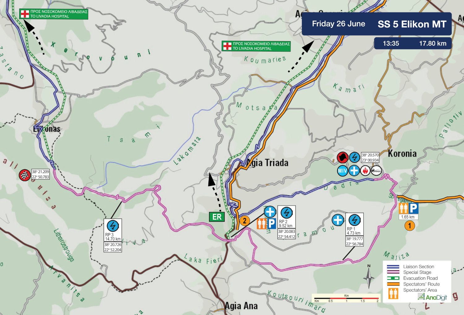
SS 5 ELIKON Mt
Length: 17.80 km
Stage closure: 10:35
First car due: 13:35
NO TAPE, NO PUBLIC
Under the FIA safety regulations, areas without safety nets, fencing, or tape are prohibited. Find your spot only in the designated areas marked with safety precautions or in elevated spots.
INFO: Select your viewing point at least 30 minutes before the start of the special stage. After this time, no movement will be permitted on the road, including in the start and finish areas.
Access points are categorised by road surface difficulty, with the category letter in bold next to each access number.
The categories are:
• S = Soft = Passenger car
• M = Medium = SUV
• H = Hard = 4x4 or Enduro motorcycle
DESCRIPTION
This is a variation of the Livadeia stage used in previous years. The route starts on the Koroneia tarmac road and, right from the beginning, passes through the well-known “McRae river”, as older fans still call it. Although the surface there is tarmac, beneath the plane trees the setting offers a truly spectacular viewing environment, despite the very limited available space. After a further 1.30 km, the route turns right and crosses two quarry sections. Before reaching the PPC facilities, the stage continues through a new section introduced for this year, approximately 2.50 km long, which rejoins the tarmac by crossing it. From there, it passes through the beautiful Elikonas section before finishing just before the village of the same name.
SPECTATOR ACCESS
1 (S-Μ)
Driving on the Thiva–Livadia National Road, take the exit towards Petra village, where the route description begins. After 1 km, you reach the village square, where you continue right towards “EVANGELISTRIA 6”.
After 150 m., at a fork where there is a cemetery and a “Καταρράκτης” sign on the right, turn left. A further 130 m. later, at a junction, continue right. Follow the road for 4.1 km, where at an uphill junction you turn right.
After 150 m., at a fork, continue straight ahead. A further 270 m. later, at another fork, take the left-hand road. After 1.7 km, continue right and uphill. After 280 m., at the point where there is a “ΚΤΗΜΑ ΑΓΓΕΛΟΣ” sign, turn right onto a narrow road.
After 130 m., at a junction, continue right and, 240 m. later, at a fork, take the left-hand road. The surface turns to gravel 100 m. later. Follow the wide gravel road for 5.8 km until you reach the 1.65 km of the special stage.
Click to navigate
SS 5 ELIKON Mt ACCESS 1 (1.65 km)
2 (S)
Driving on the Thiva–Livadia road, turn left towards “Ag. Triada”, “Ag. Anna” and “Domvrena”. After 2.0 km, turn left and, 5.77 km later, enter the village of Agia Triada, which you pass through.
After a further 2.85 km, you reach the 9.52 km of the special stage, where the route crosses the tarmac road and continues towards Elikonas.
Caution: 2 km after leaving Agia Triada, the Police will block the left-hand access road leading to the start of the special stage. Continuing for a further 800 m. beyond this point, the road reaches the 9.52 km of the special stage.
Traffic will be stopped 500 m. before the special stage, as the road serves as an emergency ambulance escape route. Do not block the road. Blocking an escape route may result in the cancellation of the special stage.
Click to navigate
SS 5 ELIKON Mt ACCESS 2 (9.52 km)
FRIDAY 26 JUNE 2026
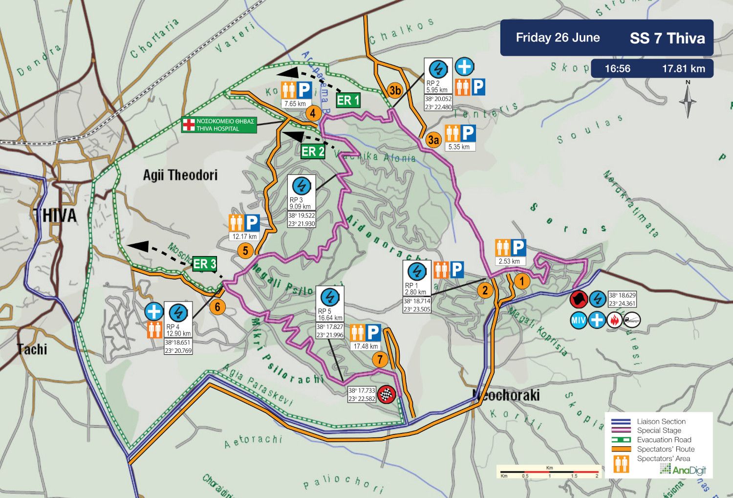
SS 7 THIVA
Length: 17.81 km
Stage closure: 13:56
First car due: 16:56
NO TAPE, NO PUBLIC
Under the FIA safety regulations, areas without safety nets, fencing, or tape are prohibited. Find your spot only in the designated areas marked with safety precautions or in elevated spots.
INFO: Select your viewing point at least 30 minutes before the start of the special stage. After this time, no movement will be permitted on the road, including in the start and finish areas.
Access points are categorised by road surface difficulty, with the category letter in bold next to each access number.
The categories are:
• S = Soft = Passenger car
• M = Medium = SUV
• H = Hard = 4x4 or Enduro motorcycle
DESCRIPTION
This year’s Thiva stage combines past layouts with its classic features, like the downhill jump and tight turns around the barrels.
SPECTATOR ACCESS
1 (S)
Driving on the Neochoraki–Schimatari Provincial Road, pass through Neochoraki village heading towards Asopia. Reset your trip meter at the point where there is a fenced yellow warehouse on the left.
Ignore the first gravel road on the left after 500 m. and, after 700 m., turn left onto an uphill concrete road. After 40 m., as the road surface turns to gravel, ignore the gravel road on your left. At the next fork, continue left.
After 450 m., you will find a gravel road on your right where you can park. From there, after an approximately 80 m. walk, you will reach a spectacular jump at the 2.53 km of the special stage.
Click to navigate
SS 7 THIVA ACCESS 1 (2.53 km)
2 (S)
Heading towards Asopia on the Neochoraki-Schimatari Provincial Road, pass through Neochoraki village. Reset your trip meter at the point where there is a fenced yellow warehouse on the left.
After 500 m., turn left onto a very good gravel road. After 450 m., you reach the 2.80 km of the special stage.
Click to navigate
SS 7 THIVA ACCESS 2 (2.80 km)
3a (H)
Heading on the Thiva–Chalkida Provincial Road, turn at the junction towards Jumbo Thiva. Reset your trip meter at this point and continue on tarmac for 600 m.
After passing a gravel road on the left and immediately afterwards another one on the right with a “ΧΥΤΑ Θήβας” sign, turn left. After 500 m., you will see the landfill entrance and a sign of the Ministry of Environment and Energy. At the point where the fencing begins, turn right onto a rough uphill gravel road.
After 1.23 km, you reach the 5.35 km of the special stage.
Click to navigate
SS 7 THIVA ACCESS 3a (5.35 km)
3b (M)
Heading on the Thiva–Chalkida Provincial Road, turn at the junction towards Jumbo Theva. Reset your trip meter at this point and continue on tarmac for 600 m.
After passing a gravel road on the left and immediately afterwards another one on the right with a “ΧΥΤΑ Θήβας” sign, continue left. After 200 m., you will find a medium-quality uphill gravel road on your right.
Park along the first 400 m., on one side of the road only and facing the direction of departure. From this point, continue on foot for 300 m. until you reach the 5.95 km of the special stage.
Caution: This road serves as an emergency ambulance escape route and must be kept clear at all times. Obstructing access may result in the cancellation of the special stage.
Click to navigate
SS 7 THIVA ACCESS 3b (5.96 km)
4 (S)
Heading on the Thiva–Chalkida Provincial Road, take the exit towards Thiva Hospital. Continue straight for 850 m. and park according to the organisers’ instructions.
From the junction, continue on foot along a gravel road for approximately 550 m. until you reach the 7.65 km of the special stage.
Caution: This road serves as an emergency ambulance escape route and must be kept clear at all times. Obstructing access may result in the cancellation of the special stage.
Click to navigate
SS 7 THIVA ACCESS 4 (7.65 km)
5 (S-M)
Heading on the Thiva–Chalkida Provincial Road, take the exit towards Thiva Hospital. Continue straight ahead and, after 850 m., turn right onto an uphill gravel road.
Follow the wide gravel road for 1.7 km. At the next fork, turn right and, after a further 900 m., you reach the 12.17 km of the special stage.
Click to navigate
SS 7 THIVA ACCESS 5 (12.17 km)
6 (S)
Approaching from either direction on “Οπλαρχηγού Βόγκλη” Street, turn at the junction where the Evangelist Loukas Church is located, following the signs towards “Μοσχοπόδι / Δασαρχείο / Κοιμητήριο Θήβας.”.
After 700 m., pass the Forestry Office and continue straight towards the Moschopodi Theatre. After 800 m., at the junction, turn right towards the “CASTELLO” restaurant.
After 400 m., park in the open area, according to the marshals’ instructions. From there, continue on foot along an uphill gravel road for approximately 450 m. until you reach the 12.90 km of the special stage, at the well-known barrel junction.
Attention: This road serves as an ambulance emergency exit. It must remain clear at all times. Blocking the escape route may result in the cancellation of the special stage.
Click to navigate
SS 7 THIVA ACCESS 6 (12.90 km)
7 (S)
Approaching either from Theva or Erythres, turn at the junction towards Neochoraki village, where you should reset your trip meter. Continuing on the Neochoraki–Schimatari National Road, after 4.9 km you will pass a gravel road on the left leading to the special stage STOP control.
Immediately afterwards, you will see a Traffic Education Park on your left and a football field on your right. At the end of both fenced areas, turn left onto an easy gravel road, where there is a sign reading “ΠΡΟΣ ΠΙΣΤΑ ΜΗΧΑΝΟΚΙΝΗΤΟΥ ΑΘΛΗΤΙΣΜΟΥ MOTOCROSS ΘΗΒΑΣ”.
After 1.4 km, follow the narrow road on the left, which immediately leads to a junction where you turn left again. A further 650 m. later, you reach the 17.48 km point of the special stage.
Click to navigate
SS 7 THIVA ACCESS 7 (17.48 km)
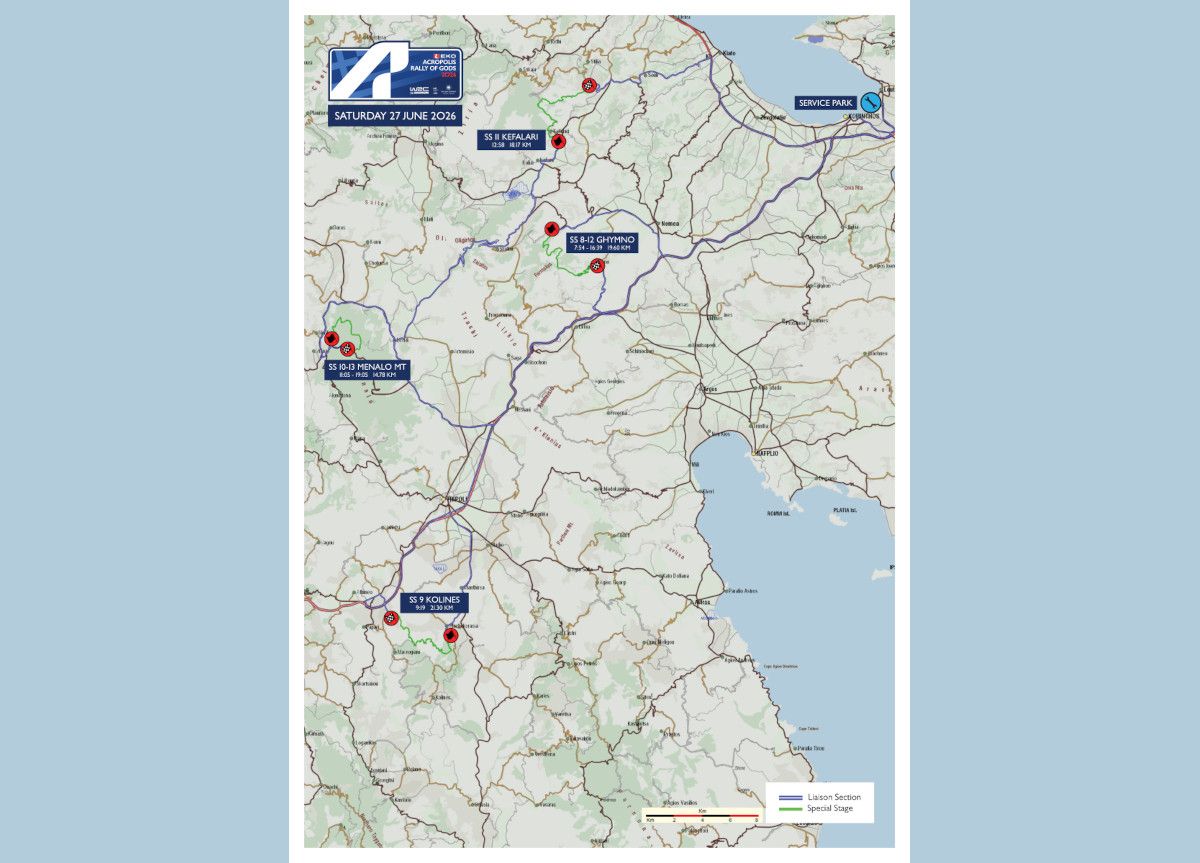
SATURDAY 27 JUNE 2026
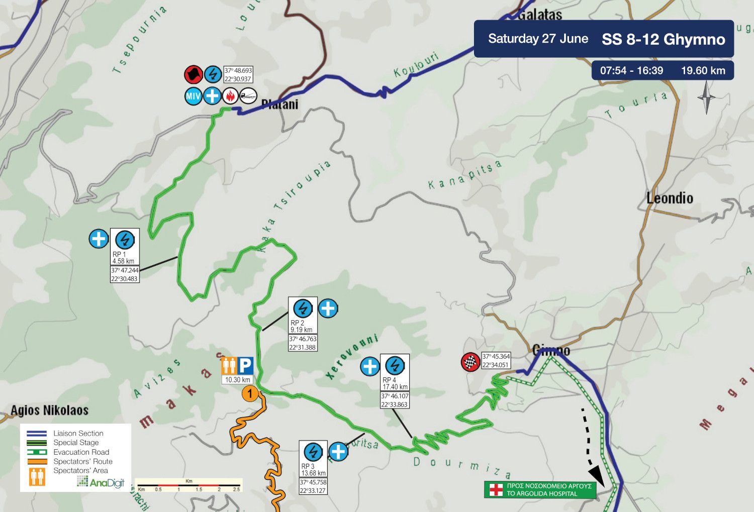
SS 8 - 12 GHYMNO
Length: 19.60 km
Timetable
Road closing time: 05:54
First car due: SS 8 07:54
SS 12 16:39
NO TAPE, NO PUBLIC
Under the FIA safety regulations, areas without safety nets, fencing, or tape are prohibited. Find your spot only in the designated areas marked with safety precautions or in elevated spots.
INFO: Select your viewing point at least 30 minutes before the start of the special stage. After this time, no movement will be permitted on the road, including in the start and finish areas.
Access points are categorised by road surface difficulty, with the category letter in bold next to each access number.
The categories are:
• S = Soft = Passenger car
• M = Medium = SUV
• H = Hard = 4x4 or Enduro motorcycle
DESCRIPTION
Back in the 2010s, this special stage had earned a reputation as one of the roughest car-breakers of the rally. Nowadays, however, anyone who manages the opening 10 km -which will be improved before the event- will be rewarded with the remaining 9.50 downhill km, arguably among the most beautiful sections of the EKO Acropolis Rally 2026.
SPECTATOR ACCESS
1 (Η)
Heading on the Corinth–Tripoli National Road, take the exit towards Astros at the Sterna junction. After 1.30 km, you reach a junction where the road to the right is signposted “ΣΤΕΡΝΑ - ΓΥΜΝΟ - Τζιρίστρα”. Turn right and follow the route for 3.30 km, until you find a downhill tarmac road on the left with a sign reading “Τζιρίστρα 3”.
Follow the road to the village. In the square, where there is a fountain on the left, turn right and immediately afterwards left onto an uphill concrete road. After passing through the village, the road turns to gravel 500 m. later.
After 3 km, you will pass a livestock pen with abandoned vehicle bodies and, continuing ahead, you will find a sign on the left reading “Παναγιά - Κοτρωνάς - Κανάλια”. The navigation link below leads up to this sign. Continue right and, after 400 m., you reach the 10.30 km of the special stage.
Click to navigate
SS 8-12 GHYMNO ACCESS 1 (10.30 km)
Notes
• The access route from the beginning of the gravel road to the 10.30 km point of the special stage, covering a total distance of 8.80 km, is very steep, narrow and in poor condition, with no room for vehicles travelling in opposite directions to pass.
• It is recommended to leave after the end of the special stage following the direction of the rally route and only after receiving approval from the marshals. Alternatively, you may relocate to another point closer to the finish after the end of the first pass, again only if authorised by the marshals.
SATURDAY 27 JUNE 2029
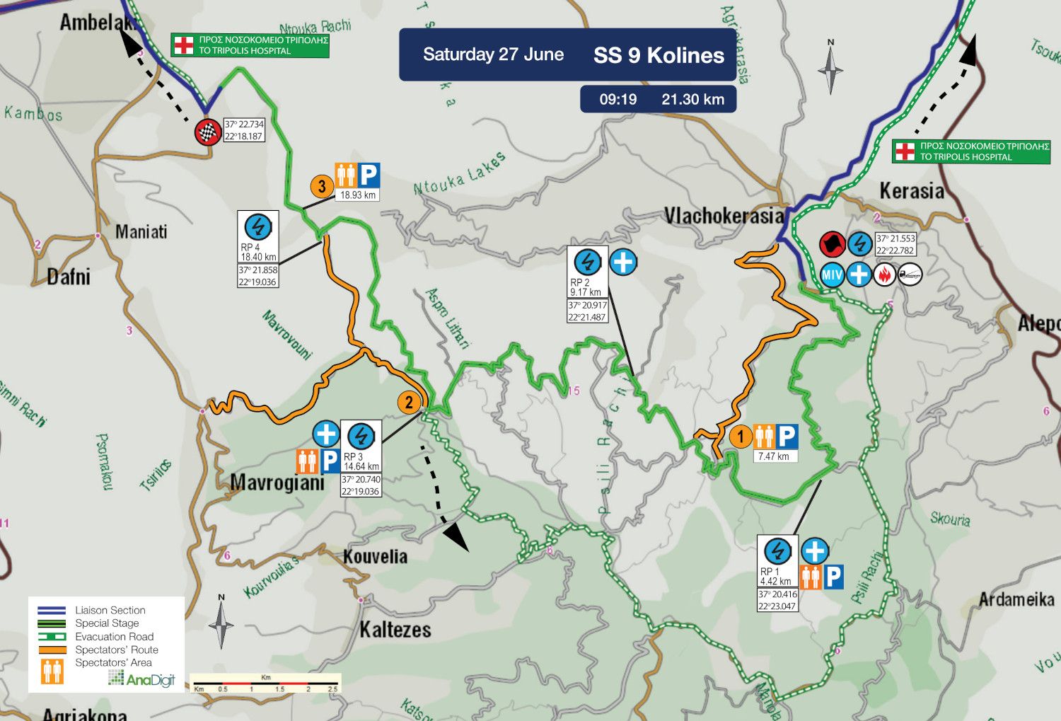
SS 9 KOLINES
Length: 21.30 km
Timetable
Road closing time: 06:19
First car due: 09:19
NO TAPE, NO PUBLIC
Under the FIA safety regulations, areas without safety nets, fencing, or tape are prohibited. Find your spot only in the designated areas marked with safety precautions or in elevated spots.
INFO: Select your viewing point at least 30 minutes before the start of the special stage. After this time, no movement will be permitted on the road, including in the start and finish areas.
Access points are categorised by road surface difficulty, with the category letter in bold next to each access number.
The categories are:
• S = Soft = Passenger car
• M = Medium = SUV
• H = Hard = 4x4 or Enduro motorcycle
DESCRIPTION
A brand-new and extremely narrow special stage, starting from Vlachokerasia village and running entirely through dense forest, making spectator viewing particularly challenging.
One of the highlights of the stage is crossing a deep river at 18.93 km before the finish.
SPECTATOR ACCESS
1 (M-H)
The route description starts in Vlacherasia village, at the point where there are signs reading “Kollines 18” and “Kaltezes 16”, where you turn left.
After 400 m., at the point where there is a roadside shrine and a house, enter diagonally right onto a concrete road and immediately afterwards turn right at the fork. After 50 m., the road turns to gravel.
After 200 m., at a junction, continue left. A further 670 m. later, ignore a road behind to the right. After approximately 1.80 km, ignore another road behind to the right.
After 1.30 km, at the point where there is a sign reading “towards Amonitsa”, take the road to the right.
Attention: From this point onwards, the uphill road is suitable only for pure four-wheel-drive vehicles.
After 450 m., you reach the 7.47 km of the stage. A further 50 m. on foot will take you to a crest section.
Click to navigate
SS 9 KOLINES ACCESS 1 a-b (7.47 km)
2 (M)
Approaching from Maniatis village towards Mavrogiannis village, reset your trip meter at the exit of Mavrogiannis village. After 2.52 km, at a fork with signs reading “Mavrogiannis 1” and “Monastery of Kaltezes 4”, turn left.
After 200 m., at the point where there is a sign reading “ΑΓΙΑΝΝΗΣ 0.5”, turn sharply left onto an uphill concrete road. After 600 m., at the church, the surface turns to gravel.
After 50 m., at a fork, continue uphill to the left. After 2.3 km, ignore a road behind to the right. A further 140 m. later, at an uphill junction, continue straight ahead.
After 1.16 km, you reach the 14.64 km of the special stage.
Caution: The road to the left serves as an emergency ambulance escape route and must be kept clear at all times. Obstructing access may result in the cancellation of the special stage.
Click to navigate
SS 9 KOLINES ACCESS 2 (14.64 km)
3 (H, 4x4 and enduro only)
Approaching from Maniatis village towards Mavrogiannis village, reset your trip meter at the exit of Mavrogiannis village. After 2.52 km, at a fork with signs reading “Mavrogiannis 1” and “Monastery of Kaltezes 4”, turn left.
After 200 m., at the point where there is a sign reading “ΑΓΙΑΝΝΗΣ 0.5”, turn sharply left onto an uphill concrete road. After 600 m., at the church, the surface turns to gravel.
After 50 m., at a fork, continue uphill to the left. After 2.3 km, ignore a road behind to the right. After 140 m., at an uphill junction, turn sharply left. A further 660 m. later, ignore a road behind to the left. After 130 m., at a fork, continue left. After 650 m., turn left and, 380 m. later, you reach the 18.93 km of the special stage.
Continuing on foot for 500 m. -and at least 2 hours before the start of the stage- you will reach a river crossing point.
Click to navigate
SS 9 KOLINES ACCESS 3 (18.93 km)
SATURDAY 27 JUNE 2026
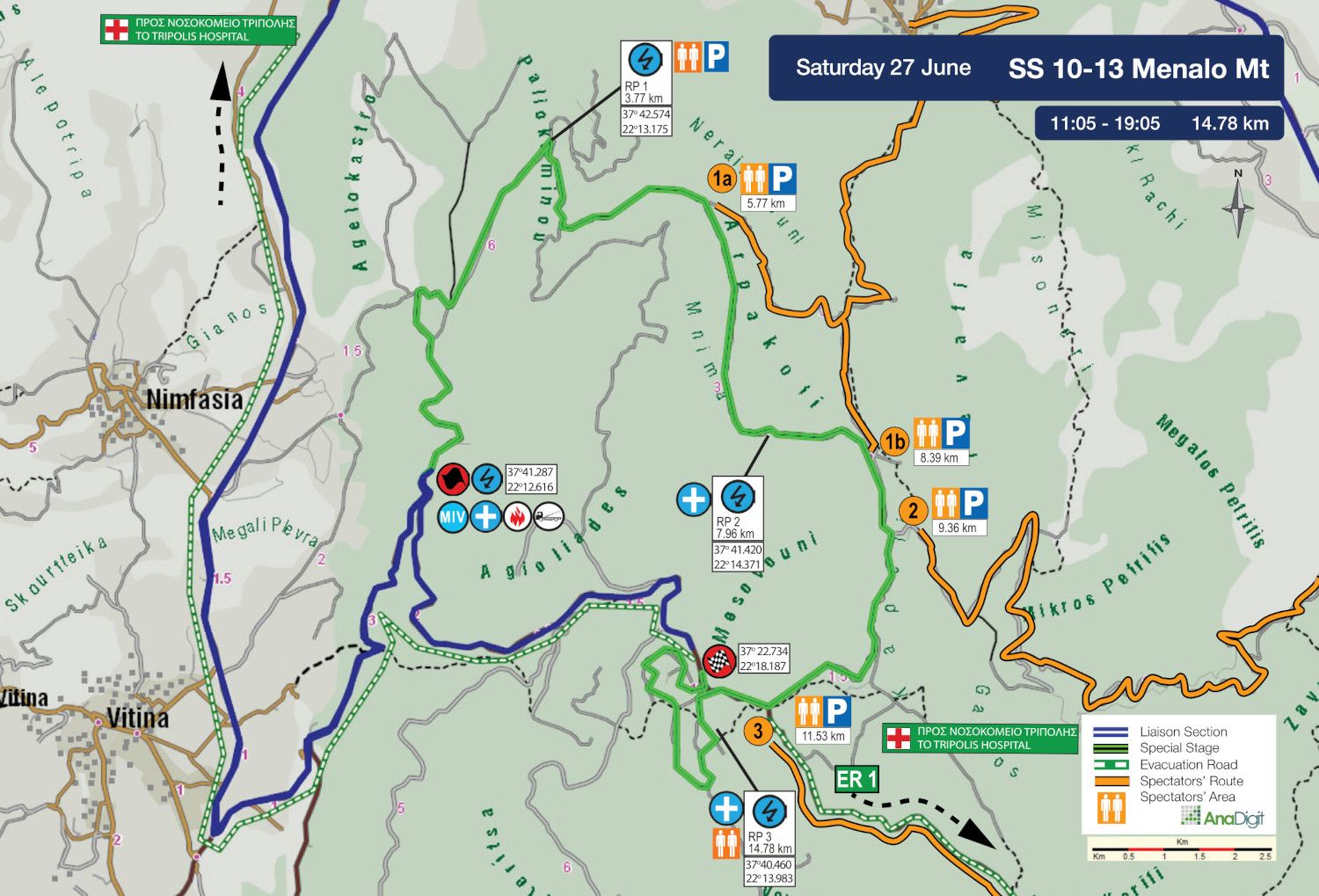
SS 10 - 13 MENALO Mt.
Length: 14.78 km
Timetable
Road closing time: 08:05
First car due: SS 10 11:05
SS 13 19:05
NO TAPE, NO PUBLIC
Under the FIA safety regulations, areas without safety nets, fencing, or tape are prohibited. Find your spot only in the designated areas marked with safety precautions or in elevated spots.
INFO: Select your viewing point at least 30 minutes before the start of the special stage. After this time, no movement will be permitted on the road, including in the start and finish areas.
Access points are categorised by road surface difficulty, with the category letter in bold next to each access number.
The categories are:
• S = Soft = Passenger car
• M = Medium = SUV
• H = Hard = 4x4 or Enduro motorcycle
DESCRIPTION
Another brand-new special stage, set in an exceptionally beautiful natural landscape above Vytina. The route is expected to excite both crews and spectators, who will have access, among other viewing points, to a specially designated Spectators’ Area on a plateau just before the finish of the stage, offering particularly easy access.
SPECTATOR ACCESS
1) From Vlacherna
On the Tripoli-Olympia road, turn left before the pharmacy located immediately after the junction. After 500 m., continue straight ahead uphill. A further 110 m. later, at the point where there is a sign reading “towards Monastery of Panagia Eleousa” and a roadside shrine, turn left, where the surface turns to gravel. At 2.10 km, at a junction, continue diagonally right onto a gravel road. After 3.25 km, at a fork, continue right. After 350 m., at a junction, continue straight ahead. After 500 m., you reach a junction. From here, you have two options:
a) Turn right and, after 2 km, you reach the 5.77 km of the stage.
b) Continue straight ahead and, after 1.10 km, you reach the 8.39 km of the stage.
Click to navigate
SS 10-13 MENALO ACCESS 1_a_b (5.77 km + 8.39 km)
2 (M) From Levidi
Driving on the Tripoli-Olympia road, you reach Levidi square, where you reset your trip meter and continue right. Immediately afterwards, turn left and then left again onto an uphill road. After 70 m., at the point where there is a sign reading “Athens”, continue straight ahead. After 600 m., at a fork, continue left onto an uphill gravel road. At 3.4 km, at another fork, continue right. After 4.5 km, you reach the 9.36 km of the stage.
Click to navigate
SS 10-13 MENALO ACCESS 2 (9.36 km)
3 (S) Mainalo Ski Centre
Note: Parking will be available at the chalet parking area of the Mainalo Ski Centre, where event shuttle buses will transport spectators to the point described in Access 3. The shuttle buses will operate to and from the Ski Centre from 08:00 to 14:00 and from 17:00 to 23:00.
For those choosing to use their own vehicle, the route description starts at the fork located 100 m. before the entrance to the Ski Centre. However, the use of the event shuttle buses is strongly recommended, as available parking space will become increasingly limited closer to the start time of the stage and access towards the special stage will gradually be restricted by the Police.
After parking, continue on foot to reach the 11.53 km of the stage. There, at a specially designated plateau area in Rouchoi, spectators will be able to follow a large part of the route from an open viewing point offering excellent visibility and continuous action.
Attention: This road serves as an emergency ambulance escape route and must remain open at all times. Obstructing access may result in the cancellation of the special stage.
Click to navigate
SS 10-13 MENALO ACCESS 3 (11.53 km)

SATURDAY 27 JUNE 2026
SS 11 KEFALARI
Length: 18.17 km
Timetable
Road closing time: 09:58
First car due: 12:58
NO TAPE, NO PUBLIC
Under the FIA safety regulations, areas without safety nets, fencing, or tape are prohibited. Find your spot only in the designated areas marked with safety precautions or in elevated spots.
INFO: Select your viewing point at least 30 minutes before the start of the special stage. After this time, no movement will be permitted on the road, including in the start and finish areas.
Access points are categorised by road surface difficulty, with the category letter in bold next to each access number.
The categories are:
• S = Soft = Passenger car
• M = Medium = SUV
• H = Hard = 4x4 or Enduro motorcycle
DESCRIPTION
The opening kilometres of the stage are outstanding. On a wide road with very good surfaces, the special stage passes through fir-tree sections in a truly spectacular natural setting, highlighted by a plateau where large numbers of spectators gather.
Mid-stage, the route shifts into a technical section with red soil, which could become difficult when wet.
SPECTATOR ACCESS
1 (S)
Heading on the Kiato-Vytina Provincial Road, take the exit towards Kefalari village at “Ο Μάγκας” taverna. After 1 km, at a junction, continue straight ahead. After 150 m., at a three-way junction, turn right and uphill. After 300 m., you reach the village square. After 50 m., at the point where there is a “Γεύση και Οίνος” sign, first keep left and immediately afterwards turn right onto the road running above the square. Continue uphill and, at a fork after 130 m., turn left and immediately afterwards right. After 320 m., the surface turns to gravel. After 350 m., you reach the 1.73 km of the stage.
Click to navigate
SS 11 KEFALARI ACCESS 1 (1.73 km)
2 (M)
The route description starts from the main parking area of Manna (Markasi) village. After 650 m., you reach the exit of the village, where there is a sign reading “ΜΑΝΝΑ Τέλος”. Follow the new tarmac road for 3.5 km. The surface then turns to gravel. Continue straight ahead for 2.45 km until you reach the 8.14 km of the stage.
Click to navigate
SS 11 KEFALARI ACCESS 2 (8.14 km)
3 (M)
The route description starts from the Klementi community office heading towards Kaisario. After 80 m., at a fork, take the road to the left. A further 40 m. later, turn right onto an uphill concrete road. After 880 m., the surface turns to gravel. After 420 m., at a fork, continue straight ahead towards a crest section. A further 950 m. later, you reach the 15.66 km of the stage.
Click to navigate
SS 11 KEFALARI ACCESS 3 (15.66 km)
4 (S)
Heading on the Kiato-Feneos road, turn right towards Velina and Klementi. After 2.4 km, at a junction, continue right and uphill. After 3.3 km, turn left and, 220 m. later, after passing the stage STOP control, turn left onto a wide gravel road.
After 700 m., at a fork, park your vehicle and continue on foot following the uphill road to the left. After a further 400 m., you reach the 17.44 km of the stage.
Click to navigate
SS 11 KEFALARI ACCESS 4 (17.44 km)
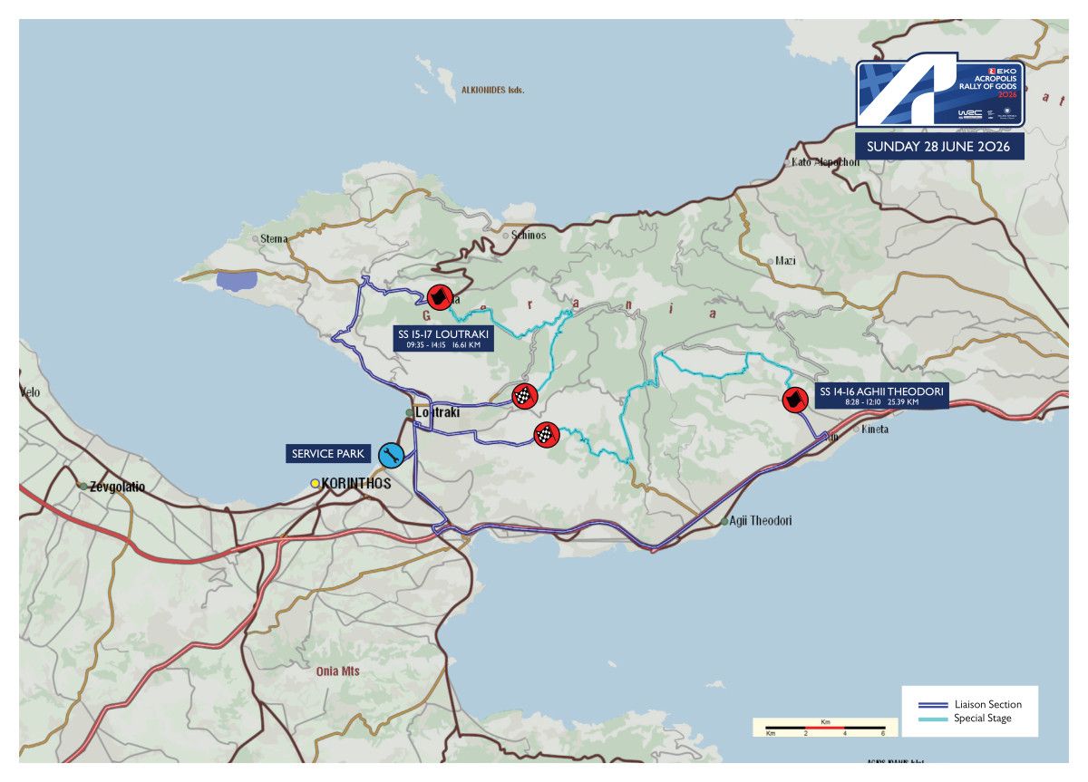
SUNDAY 28 JUNE 2026
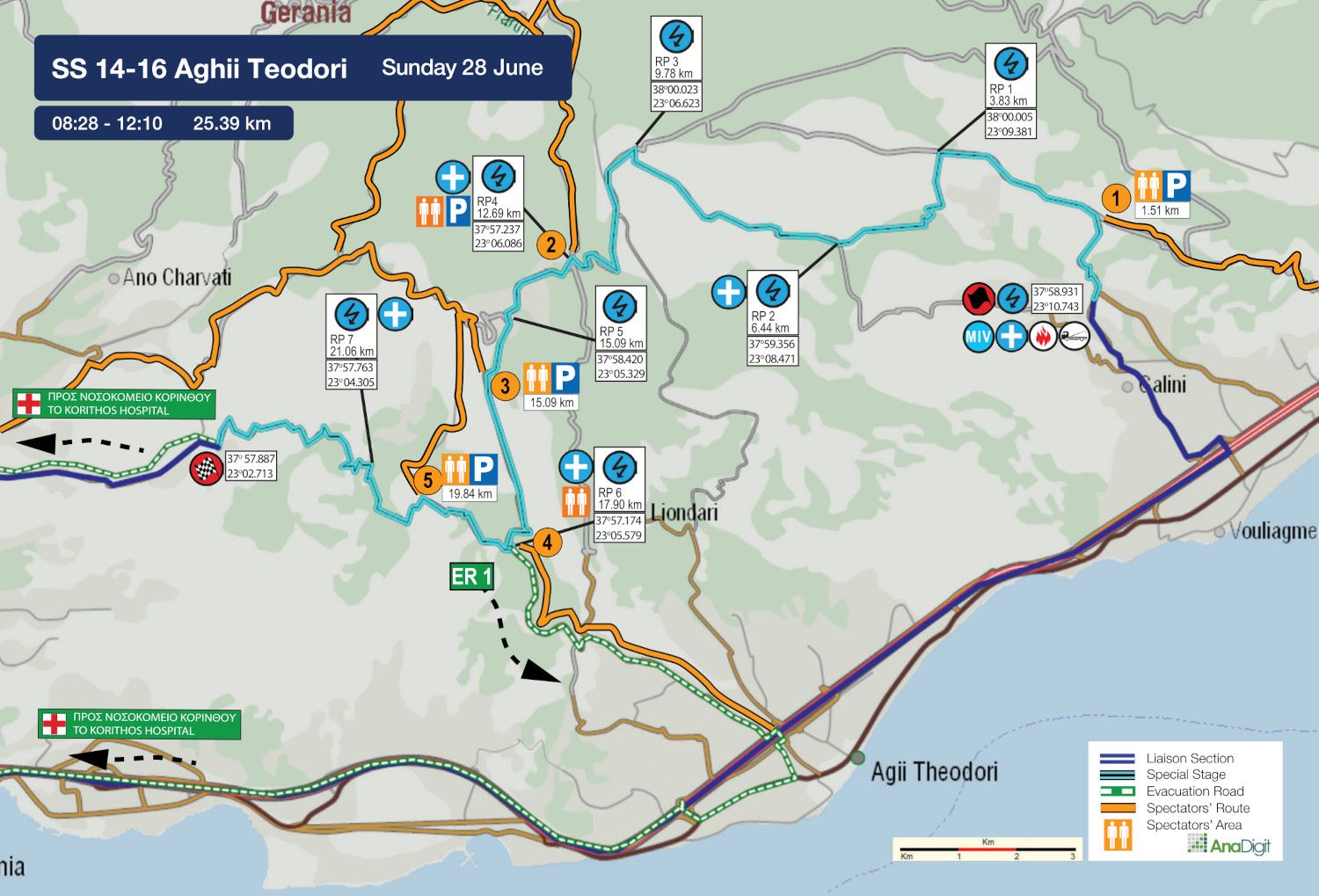
SS 14 - 16 AGHII THEODORI
Length: 25.39 km
Timetable
Road closing time: 05:28
First car due: SS 14 08:28
SS 16 12:10
NO TAPE, NO PUBLIC
Under the FIA safety regulations, areas without safety nets, fencing, or tape are prohibited. Find your spot only in the designated areas marked with safety precautions or in elevated spots.
INFO: Select your viewing point at least 30 minutes before the start of the special stage. After this time, no movement will be permitted on the road, including in the start and finish areas.
Access points are categorised by road surface difficulty, with the category letter in bold next to each access number.
The categories are:
• S = Soft = Passenger car
• M = Medium = SUV
• H = Hard = 4x4 or Enduro motorcycle
DESCRIPTION
The longest stage of the rally, measuring 25.39 km, starts from the location where the start of the former Kineta stage was situated around 20 years ago. After approximately 12 km, the route reaches the well-known “Pomona” junction and, continuing straight ahead, joins the tarmac one kilometre later.
What follows are approximately 3.50 km of fast downhill asphalt before the route turns right into the final gravel section, a highly technical part of the stage leading all the way to the Loutraki landfill area, where the finish is located.
SPECTATOR ACCESS
1 (S-M)
Heading on the Athens-Corinth National Road towards Corinth, take the exit towards Panorama Kineta and, at the first junction, continue left. After 700 m., turn right onto a road with a sign reading “Marouga Settlement”.
After 80 m., at a junction, continue straight ahead uphill. After 650 m., at another junction, continue straight ahead again. After 130 m., ignore a road behind to the left and, 50 m. later, ignore another gravel road on your left, continuing straight ahead uphill.
After 500 m., pass the last road of the settlement on your left and continue straight ahead, always uphill, on a narrow concrete road. After 820 m., the surface turns to gravel.
After 1.35 km, at a junction marked by a barrel, continue straight ahead. A further 270 m. later, at a fork, continue straight ahead once more. After 1.40 km, you reach the 1.51 km of the stage.
Click to navigate
SS 14-16 AGHII THEODORI ACCESS 1 (1,51 km)
2 (M)
Approaching from the Isthmus towards Loutraki and driving along the town’s main road, turn right onto Karantani Street at the point where the PepsiCo-Ivi factory is located on the right.
After 4.9 km, you reach a junction with a sign reading “ΝΕΑ ΠΟΛΙΤΕΙΑ - Καλώς ήρθατε”, where you turn right towards the Metamorfosi tou Sotiros chapel. At this point, the surface turns to gravel.
Follow the gravel road for 4.7 km and, at the next junction, continue left. After 5.6 km, at the point where there is a tree in the middle of the road, continue straight ahead towards Prathi.
After 500 m., at a junction, continue straight ahead downhill. A further 2.3 km later, at a fork, take the road to the right. After 2.7 km, you reach the 12.69 km of the stage, at the known “Pomona” spot.
Click to navigate
SS 14-16 AGHII THEODORI ACCESS 2 (12,69 km)
3 (S)
Approaching from the Isthmus towards Loutraki and driving along the town’s main road, turn right onto Karantani Street at the point where the «NU AQUA A.E. / Εonio Λουτράκι» factory is located on the right.
After 4.9 km, you reach a junction with a sign reading “NEA POLITEIA - Welcome”, where you turn right towards the Metamorfosi tou Sotiros chapel. At this point, the surface turns to gravel.
Follow the gravel road for 4.7 km and, at the next junction, continue right. After 3.3 km, you reach the tarmac section at the 15.09 km of the stage.
Click to navigate
SS 14-16 AGHII THEODORI ACCESS 3 (15,09 km)
TIP: Access points 2, 3 and 5 connect with Access 2 of the Loutraki stage, which passes through Prathi. This allows safe movement and spectating between both stages via the Geraneia mountain road network.
Example of the connection between Access 3 of the Agioi Theodoroi stage and Access 2 of the Loutraki stage:
Click to navigate
From SS Aghii Theodori Access 3 To SS Loutraki Access 2
4 (S)
Heading on the Athens-Corinth National Road towards Corinth, take the exit towards Agioi Theodoroi. After 360 m., you reach the toll station. A further 170 m. later, at the STOP sign, turn left and, after 1.73 km -just before the railway tracks- turn sharply left again onto the first road.
After 580 m., having passed two roads on your right, turn diagonally left. A further 220 m. later -after passing beneath the second bridge- turn left again. After another 180 m., turn right onto a narrow uphill road towards “Kiafa Beka”.
After 2.77 km, pass a gravel-road junction on your right. A further 2.3 km later, you reach the 17.90 km of the stage.
INFO: This access road serves as an emergency ambulance escape route. Please park on one side of the road only, facing the direction of departure and according to the organisers’ instructions.
Click to navigate
SS 14-16 AGHII THEODORI ACCESS 4 (17,90 km)
5 (S-Μ)
Approaching from the Isthmus towards Loutraki and driving along the town’s main road, turn right onto Karantani Street at the point where the «NU AQUA A.E. / Εonio Λουτράκι» factory is located on the right.
After 4.9 km, you reach a junction with a sign reading “ΝΕΑ ΠΟΛΙΤΕΙΑ - Καλώς ήρθατε”, where you turn right towards the Metamorfosi tou Sotiros chapel. At this point, the surface turns to gravel.
Follow the gravel road for 4.7 km and, at the next junction, continue right. After 2.2 km, turn right onto a fire access road. Following this road for 2.6 km, you reach the 19.84 km of the stage.
Click to navigate
SS 14-16 AGHII THEODORI ACCESS 5 (19,84 km)
SUNDAY 28 JUNE 2026
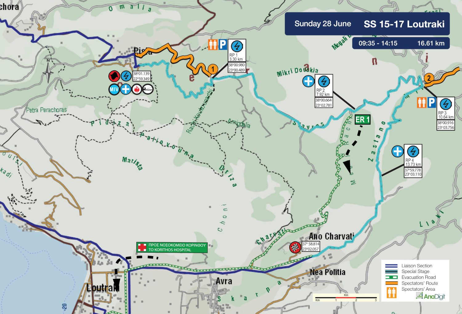
SS 15-17 LOUTRAKI + WOLF POWER STAGE
Length: 16.61 km
Timetable
Road closing time: 06:35
First car due: SS 15 09:35
SS 17 14:15
NO TAPE, NO PUBLIC
Under the FIA safety regulations, areas without safety nets, fencing, or tape are prohibited. Find your spot only in the designated areas marked with safety precautions or in elevated spots.
INFO: Select your viewing point at least 30 minutes before the start of the special stage. After this time, no movement will be permitted on the road, including in the start and finish areas.
Access points are categorized by road surface difficulty, with the category letter in bold next to each access number.
The categories are:
• S = Soft = Passenger car
• M = Medium = SUV
• H = Hard = 4x4 or Enduro motorcycle
DESCRIPTION
The Power Stage combines the opening 7 km of last year’s Loutraki stage with approximately 3 brand-new kilometres, before concluding with the final 6.50 km of last year’s Agioi Theodoroi stage.
The opening 2.80 km are particularly narrow and uphill. The route then passes through Faneromeni, a location traditionally popular with spectators, before continuing into fast downhill sections leading to the junction with the former Agioi Theodoroi layout. The stage finishes below the village of Charvati.
SPECTATOR ACCESS
1 (M)
Starting from Pisia village, head towards “Schinos”. After 0.9 km, turn right onto a narrow uphill road and, 2.10 km later, you reach the 3.20 km of the stage, at the Panagia Faneromeni church.
Click to navigate
SS 15-17 LOUTRAKI ACCESS 1 (3.20 km)
2 (M-H)
Approaching from the Isthmus towards Loutraki and driving along the town’s main road, turn right onto Karantani Street at the point where the «NU AQUA A.E. / Εonio Λουτράκι» factory is located on the right.
After 4.9 km, you reach a junction with a sign reading “ΝΕΑ ΠΟΛΙΤΕΙΑ - Καλώς ήρθατε”, where you turn right towards the Metamorfosi tou Sotiros chapel. At this point, the surface turns to gravel.
Follow the gravel road for 4.7 km and, at the next junction, continue left. After 5.6 km, at the point where there is a tree in the middle of the road, turn left onto a narrow downhill road.
After two hairpins, and 650 m. later, at a fork, continue left. After 2.6 km, ignore a road behind to the right and, 300 m. later, you reach the 10.64 km of the stage.
Click to navigate
SS 15-17 LOUTRAKI ACCESS 2 (10.64 km)
TIP: Access 2 connects with Access points 2, 3 and 5 of the Agioi Theodoroi stage. This allows safe movement and spectating between both stages via the Geraneia mountain road network.
Example of the connection between Access 2 of the Loutraki stage and Access 3 of the Agioi Theodoroi stage:
Click to navigate
From SS Loutraki Access 2 To SS Aghii Theodori Access 2, 3, 5
FINISH PODIUM CEREMONY AND PRIZE GIVING
The finish podium ceremony and prize giving will take place after the Power Stage finish on Sunday, 28th June at 15:15 hrs at Dexameni Park.